April 10, 2002
Tropical streams, rivers ‘exhaling’ millions of tons more CO2 than thought
U.S. and Brazilian researchers say the amount of carbon dioxide coming off streams, rivers and flooded areas of the world’s tropical forests is triple that of some currently accepted estimates, meaning such forests aren’t the carbon sponges some scientists believe.
The new total of 900 million metric tons (about 2 trillion pounds) of carbon given off globally by tropical-forest waterways is comparable to, for example, about a fifth of the carbon dioxide generated each year by human activities such as deforestation and burning fossil fuels.
It matches the amount that some leading modelers have speculated was missing from tropical forests when they’ve tried to tally up the worldwide movement of carbon, according to Jeffrey Richey, professor of oceanography at the University of Washington and lead author describing the new calculations in the April 11 issue of the journal Nature.
The new calculations are possible because of a NASA-sponsored program giving the researchers access to radar imagery of a kind available only in the last few years. That data was then used in conjunction with river measurements from 13 National Science Foundation expeditions to the Amazon in the 1980s and ’90s. The expeditions also were supported by the Brazilian government.
Global-carbon models come up short when using numbers from efforts in recent years to directly measure carbon dioxide in the air in, and just above, tropical forests. In contrast, Richey and his colleges said that with the new numbers for waterways, the amount of carbon dioxide is actually about even, with as much being absorbed as is released by tropical forests.
Apart from technical problems that may be occurring while trying to directly measure carbon dioxide in tropical forests, “the land-water connection appears to be far more important than anyone thought,” Richey said. He and his group determined, for instance, that 20 percent of the carbon being released from streams and rivers was from aquatic processes, while the other 80 percent originated in the forest.
There the trees and other vegetation draw carbon dioxide out of the air during photosynthesis, using the carbon to create wood cells including roots and releasing oxygen back to the atmosphere. The carbon that ends up in streams and rivers is “swept” there by rains and floods that draw carbon out of the soil and carry woody debris, leaf litter and other matter downstream.
As the material decomposes and is eaten by organisms including insects and fish, and as river conditions change, carbon dioxide is release, or degassed, from surface waters. The resulting “river breath,” as Richey termed it, turns out to be a significant downstream movement of carbon fixed by the forest.
And, although it’s long been assumed that most carbon making its way into waterways just ended up in the ocean, Richey and his co-authors found 13 times more carbon is degassed than reaches the sea.
“If you want to know where carbon from today’s tropical forest goes, look a thousand kilometers downstream in 20 or 30 years,” he said.
Co-authors on the paper are John Melack and Laura Hess of the University of California, Santa Barbara; Anthony Aufdenkampe, who just completed his doctorate with Richey at the UW and is now at the University of South Carolina; and Victoria Ballester of the Centro de Energia Nuclear na Agricultura, São Paulo, Brazil.
Their calculations are based on water chemistry measurements made by groups led by Richey in the Amazon basin, information that couldn’t be scaled up to the degree now possible because there was no way to know the extent of water in the forest over the course of a year.
That became possible with a new kind of radar, a Japanese system to which the researchers had access as part of the National Aeronautics and Space Administration’s Large-Scale Biosphere Atmosphere project. Used from satellites, the radar can measure the extent of water. The study quadrant was an area of 1.77 million square kilometers (690,000 square miles), which is more than four times the size of California.
Water covers between 8 percent and 20 percent of the study area, depending on the time of year and amount of flooding.
###
- Richey can be reached at jrichey@u.washington.edu. He has been in Buenos Aires and returns to his office in Seattle the afternoon of April 11, 206-543-7339.
- Contact Sandra Hines for information about reaching other co-authors.
- Scott Denning, assistant professor at Colorado State University, is a modeler interested in these new calculations and is willing to comment on the paper. He’s busy with meetings in Sarasota, Fla., through April 12 but he is checking his e-mail, denning@atmos.colostate.edu, twice a day, and will be checking for phone messages left at 970-491-6936.
Images are at:
http://www.washington.edu/newsroom/news/images/boat1.jpg
http://www.washington.edu/newsroom/news/images/boat2.jpg
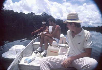
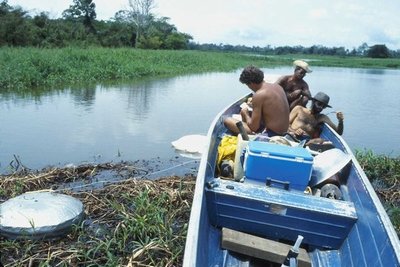
In both images, U.S. and Brazilian researchers use floating chambers to measure the flux of carbon dioxide from waters of the forest in the central Amazon basin. Photo credit: University of Washington
Tag(s): Jeffrey Richey • School of Oceanography

