September 30, 2010
80 percent of agricultural expansion in tropics came at expense of forests
Tropical forests — and not previously cleared land, as some have contended — were the primary source of new agricultural land in the tropics from 1980 through 2000, according to a paper published online in the Early Edition of the Proceedings of the National Academy of Sciences.
The paper is the first to quantify the types of land, ranging from pristine forests to shrubland, that are being converted to agriculture in the tropics around the globe.
“Before this, there were statistics showing expansion of cropland but not where the land was coming from,” says co-author Aaron Ruesch, a UW master’s student in forest resources. The UW was one of seven institutions involved in the publication.
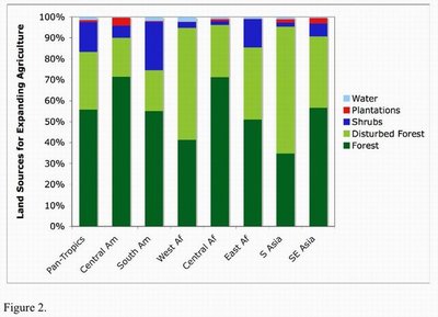
Across tropical regions, agricultural area increased by more than half a million square miles during the 1980s and 1990s. The new findings reveal that 55 percent of new agricultural lands came from intact forests. Another 28 percent came from disturbed forests, those previously affected by light logging, fuel-wood collection, spotty cultivation or other forms of gradual degradation. Most of the rest was from shrubland.
The findings confirm that agricultural expansion did not arise largely from previously cleared land, as has been contended by some agroindustrialist firms and scientists, Ruesch says.
It’s important to understand the sources of new agricultural lands because worldwide demand for agricultural products is expected to increase by about 50 percent by 2050 and evidence suggests that tropical countries will be called on to meet much of this demand, the co-authors write. Where the demand is for plant material for biofuels — the “green” alternative to gasoline — it is particularly ironic to be cutting down forests that are taking large amounts of carbon dioxide out of the atmosphere, Ruesch says.
Lead author Holly Gibbs, a postdoctoral researcher at Stanford University, came up with the idea to analyze land cover changes compiled by the United Nation’s Food and Agricultural Organization using high-resolution satellite maps from 110 sites in the tropics in 1980, 1990 and 2000. Unlike most satellite-based studies that only identify that forest area has diminished, this particular effort specifically tracked how land cover changes occurred.
In their paper, the scientists say their analysis emphasizes the need to enact economic mechanisms, or incentives, to stop forest land clearing. An example cited is the U.N.’s Reducing Emissions from Deforestation and Degradation program. The program, launched in 2008, aims to make forests more valuable where they stand than they would be cut down, by creating a financial value for the carbon stored in trees.
Other co-authors on the paper are Frederic Archard, Joint Research Centre of the European Commission, Italy; Murray Clayton, University of Wisconsin; Peter Holmgren, U.N. Food and Agricultural Organization, Rome; Navin Ramankutty, McGill University, Montreal; and Jonathan Foley, University of Minnesota.
The work was funded by the U.S. Department of Energy, NASA and the David H. Smith Conservation Research Fellowship Program.


